A few days ago, we’ve all seen the disturbing news of floods in Sikkim. But, how did it happen? And is this a recurrent event? More here.
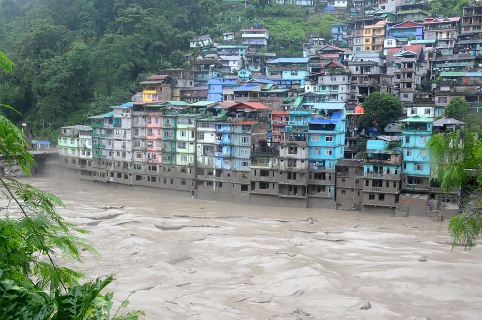
A massive flood that resulted from Glacier Lake Outburst led to many people missing and a few reported dead in the early hours of October 4th. The huge flow has also resulted in the destruction of the Chungthang Dam. This dam was critical for the Teesta 3 hydropower project, a 1200 MW plant involved in controversies as it was built on sensitive geological land.
Sikkim is a state geographically located on the hills of the Himalayas. Among the Himalayan states, Sikkim is reported to have 80 glaciers more than any other state.
But what is a Glacier Lake Outburst?
Glacier lakes are large lakes that are formed due to the melting of the glaciers. Most of these lakes are surrounded by natural dam-like structures formed from rocks and sediments.
What happened in Sikkim was a sudden outburst of such a glacier lake. Such events are termed as Glacier Lake Outburst Flood (GLOF). The Kinnaur Valley Floods in 1981 and the Kedarnath floods in 2013 are also GLOF events.
What Triggered the Sikkim GLOF event?
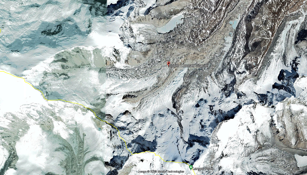
The South Lhonak glacier, located in north Sikkim, is reportedly one of the fastest retreating glaciers. The glacier receded nearly 2 km in 46 years from 1962 to 2008. It further retreated by ~400 m from 2008 to 2019. As per a report by The Hindu, there are an estimated 7,500 glaciers in the Himalayas and GLOFs have been associated with major disasters through the years.
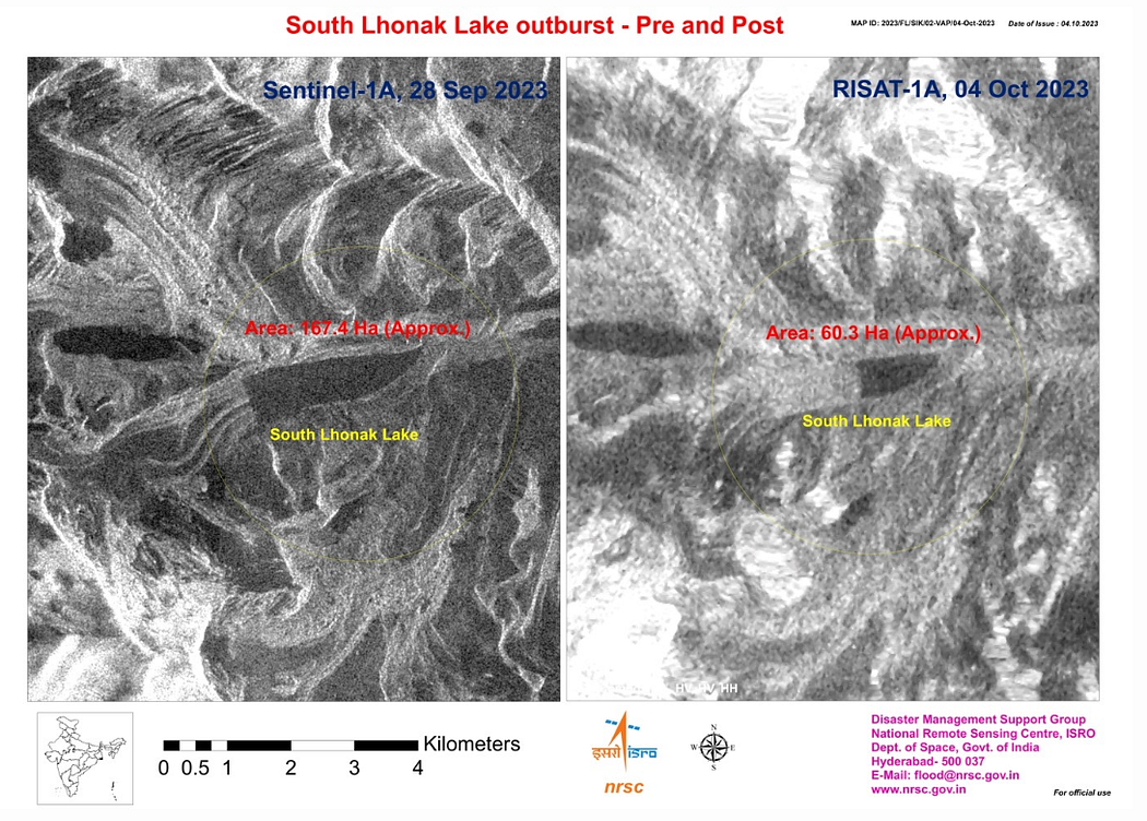
The above is a satellite image from ISRO of the South Lhonak lake which is a glacier lake, taken on 28th Sept’23 and 4th Oct’23. The area of the lake was reduced by nearly 100 Hectares (1 hectare = 10,000 square meters).
The depth of the lake can’t be determined by the satellite image, but here is what The Hindu reports:
Water-monitoring apparatus maintained by the Central Water Commission (CWC) reports that water levels surged nearly 60 feet above the maximum levels at Sangkalang at 1:30 pm and gushed at nearly 55 kmph. This is, at the very least, thousands of cubic metres of water in a short time and being midnight, gave very little lead time for people downstream to react.
The most visible damage reflecting the ferocity of the floods was the destruction of the Chungthang dam in just 10 minutes. The flood also destroyed 11 bridges, water and sewage pipelines connecting houses in the neighbouring districts.
Why did this happen?
There were several studies suggesting the possibility of such events in this region. One of the studies mentions this:
The Teesta basin in Sikkim Himalaya hosts numerous glacial lakes in the high altitude glacierized region, including one of the largest and the fastest-growing South Lhonak Lake. While these lakes are mainly located in remote and unsettled mountain valleys, far-reaching glacial lake outburst floods (GLOFs) may claim lives and damage assets up to tens of kilometers downstream. Therefore, evaluating GLOF hazard associated with current and potential future glacier-retreat-driven changes is of high importance. In this work, we assess the future GLOF hazard of the South Lhonak Lake by integrating glacier and hydrodynamic modeling to calculate the lake’s future volume and hydraulic GLOF characteristics and impacts along the valley. We identify the increased susceptibility of the lake to potential avalanche impacts as the lake grows in the future. Mapping infrastructure exposed to GLOFs in the Teesta valley shows that many settlements and assets located along the river channel at Chungthang are potentially exposed to future GLOFs, indicating the need to conduct a full environmental impact assessment and potentially undertake GLOF risk mitigation measures.
There was severe rainfall to the South of this lake and an earthquake in Nepal on Oct 3 that might have caused this disaster.
With the ongoing climate change leading to increasing heat and bursts of sudden rainfall, the ecosystem at the glaciers is more fragile than ever. It is highly important that consistent monitoring of the disturbances in these regions is required to map out the hazard regions and take precautions accordingly.
What do you think?